| The Analogous Landscape: Rim of Fire
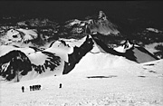
Defining the nature of resemblance between things that are otherwise unlike is the focus of The Analogous Landscape project. In the tradition of monumental works by environmental artists Robert Smithson, James Terrill, Christo, Richard Long and the Harrison's, C5 intends to produce a large scale conceptual and performance artwork. The Analogous Landscape: Rim of Fire project integrates a sophisticated research agenda within the context of adventure sports, corporate culture and art. Beginning with the successful expeditions in 2003 to ascend Mt. Shasta and Mt. Whitney in California (the highest peak in the continental United States) C5 is planning research expeditions with the intent of climbing 20 volcanic mountains along the Pacific Rim of Fire. The environmental space of the Pacific Rim is a complex dynamic shaped by a context of economic globalization and post-modernization.
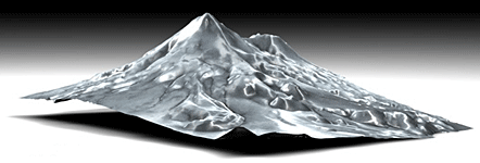
The objective of The Analogous Landscape: Rim of Fire project is to develop inferencing techniques for navigation of terrains of similar characteristic. At issue is whether navigation paths can be transposed by analogy on a selected terrain's other. To address this, initial expeditions will be analyzed to produce predictive navigation scenarios that can be imposed on the succession of expeditions. C5 intends to re-describe the landscape as a factor of expeditionary experience. Using GPS (Global Positioning Systems) technology C5 research teams will collect ascent path tracking data that will be computer modeled in three dimensions. Video and photographic documentation of the expeditions will be interactively linked to the tracking data (time and location data) through a unique computer interface design. Each mountain will be computer fabricated directly from space shuttle and satellite DEM (Digital Elevation Mapping). A singular model will be produced directly from a cumulative integration of the track logs. The final installation will include the above elements within an interactive display environment.
View exhibition documentation of The Analogous Landscape, from The C5 Landscape Initiative debut exhibition at San Francisco Camerawork.
|